Monday, October 21, 2013

Avoid, Shift, Improve: CO2e and the Bike Commuter


Having already reached my goal of 4500 miles of commuter cycling for the year, I raised the bar to 5500 miles (6000 miles if you listen to the goading of my friend Todd). Looking back, I began to wonder about the differences in CO2e (CO2 emissions) for the 4500 miles of cycling versus 4500 miles of driving. A little web research uncovered this study from the European Cycling Federation (ECF) - Cycle more Often 2 cool down the planet: Quantifying CO2 savings of Cycling. Released in November of 2011, this guide attempts account for all the CO2e involved in transportation by bicycle and by car. This includes not just the emissions involved daily use, but also those that result from producing and maintaining automobiles and bikes. The study also attempts to account for CO2e related to the production of food that cyclists must consume to fuel their cycling. Though this study focuses on the EU (European Union), it is nevertheless an interesting read and can be used to make broad assumptions about CO2e in the US. And it helped to estimate just how much CO2e I had contributed by cycling 4500 miles (7200 km).

When considering GHG (greenhouse gas) emissions, the study estimates the amount of raw materials in the average bike, assumes a lifetime of 8 years, and a distance traveled of about 2400 km per year to arrive at 5 grams CO2e/km. The authors assume the average cyclist weighs 70 kg (155 lbs), travels at 16 kph (10 mph), and burns about 4 kilocalories per kilogram per hour. There are various ways to try to determine the GHG  emissions related to a cyclist's diet, but that depends on the cyclist's diet because some foods (like meat) require more energy to produce. In the end, the study concludes that cycling contributes 21grams CO2e/km. The average car contributes 271 grams CO2e/km. If you're not particularly fit physically, consider that electric-powered/assisted bicycles have an estimated CO2e of just 22 grams/km.

I weigh 78 kg (about 172 pounds) and average about 26 kph (16 MPH) on my bike commute, so I probably generate slightly more than 21grams CO2e/km. With all my gear, my bike is close to the 19.9 kg (44 pounds) assumed in the study, but I cycle considerably more per year. So I assumed 22 grams CO2e/km and given that 4500 miles is 7242 kilometers, I generated about 329 kilograms CO2E (or 725 pounds). Driving that same distance would have generated about 1962 kilograms of CO2e (or 4326 pounds - just over 2 tons US). That's 6 times more CO2e for driving versus cycling. If you're thinking the discussion of CO2e and cycling falls into the category of "who cares?" consider that in the European Union (EU), about a quarter of all GHG are produced by transportation.

While there are similar statistics for the US, I've focused on the ECF's study for two reasons: One is that they have nicer, simpler graphics and two, the study shows how various strategies for increasing bicycling as transportation could help EU countries meet the stated CO2e goals for the year 2050. By contrast, the EPA's CO2e reduction strategies look decidedly disorganized and ineffectual. Just sayin' ...


The ECF study suggests three strategies that could be used independently or in combination to meet goals to reduce CO2e - Avoid travel, shift travel to public transportation and non-motorized transportation and improve the CO2e footprint for motorized transport, If you've been thinking there's nothing you can do to significantly reduce CO2e by cycling more and driving less, consider these graphics from the study.


Tuesday, September 24, 2013

Connect the Cycling Dots

A hectic schedule makes it hard to maintain two blogs and I'm the first to admit I've fallen a bit behind, so here's a bit of a hodgepodge of cycling stuff. I sometimes fear this blog is beginning sound like Mr. Pither, the cyclist attempting a tour of North Cornwall in an old Monty Python episode. If you find cycling stuff boring, you can skip the rest of this post and just watch the clip below.


Sport-Utility Bike

My Yuba Mundo continues to see a lot of use: Trips to the grocery, Costco runs, and the occasional trip to PetVet to stock up on dog food and supplies. It's surprising how often an SUB can alleviate the perceived need for driving a car. Less CO2 output and more exercise. Think about it ...


Sierra Cycling

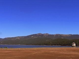
A mountain flying instructional flight, combined with the pilot's need to attend a meeting, meant I had a three plus hours to myself. Once again, I packed my Bike Friday Tikit and did some cycling around Lake Almanor. 

Tikit, secured in DA40 baggage area
Upon arrival, I discovered the rear fender had given up the ghost. The design is somewhat suspect: Two metal washers, sandwiched around a hole in the plastic fender, secure the rear of the fender to the Tikit's folding rack. A bit of pressure in the wrong place (such as when stuffing the bike into a cargo hold) and the plastic is broken. Luckily, I scrounged a bit of aviation safety wire from the kind folks at the FBO at Chester Rogers Field and managed a makeshift repair. With some pointers from the woman at the FBO, I elected to circumnavigate Lake Almanor starting out to the south.

No bubblegum required ...

Air Attack Helicopter


Wide shoulder/bike lane


Empty Spillway
Minimal/no bike lane on the East/North side of the lake

Rolling hills, less shade on the north side of lake


Entering Chester, CA

Arriving in Chester, I stopped for a double espresso and a cookie at the Coffee Station. Having had time to think about the routes I've cycled in SoCal, the California Central Coast, and now the northwest Sierra, the idea occurs to me that at some point I'd like to connect the dots. Cycling from the Bay Area to San Diego would be an interesting challenge. Of course, I'll need plenty of sandwiches, cheese, bananas, and of course, hardboiled eggs ...

Sunday, September 15, 2013

SoCal Cycling

Events conspired and I found myself visiting Southern California twice within a week's time. Ever aware of my cycling goal of logging 4,500 miles this year (currently just over 4000 miles) and the effect that traveling might have on my cycling routine, I again put my folding BikeFriday Tiki to good use. On the first trip I drove to San Diego. The second trip was an instructional flight in a DA40 with an overnight stay in Temecula. In both cases, I packed my Tiki and logged a few good rides.

We've driven to San Diego many times, but usually choose make it a humane, two-day trip via US 101 with an overnight stop on the Central Coast. This time I drove solo with our two Basenji, straight (pretty much) to San Diego in 10.5 hours with three minimal rest stops. It would have been 9.5 hours, but there was an hour delay on I-5 due to an accident involving a truck hauling what looked like tomatoes. Spending one hour to cover 2 miles didn't help my mood. Approaching the Gorman Pass, Waze decided it was best to route me through the Antelope Valley via the Pearblossom Highway to I-15 rather than through the LA basin. Towering cumulonimbus clouds loomed in the sky as we drove along the two-lane blacktop and a light rain began falling. My mood improved, at least until I hit Friday rush hour traffic near Riverside.

A tree grows in San Diego!

There are few areas of grass or dirt in the area surrounding the downtown San Diego hotel where we were staying and that had our dogs frustrated. Clearly they wanted to get their feet and their noses in contact with the earth, not cement, brick and asphalt. We walked four blocks before we found a park and they were much happier. It's amazing how we humans have become accustomed to paving over the natural world.


With a heat wave gripping SoCal, I decided to rise early the next morning and do a bike ride while the air was cool. Staying along the Pacific Ocean would help, so I researched various bike rides with GoogleMaps (really liking the new bike routing on the iPhone) before choosing a trip to Point Loma and the Cabrillo National Monument. There were plenty of cyclists and walkers on the trail near Harbor Drive. Most were friendly, save the competitive group of cyclists I encountered. One of them dismissively informed me that my Tikit was "a piece of crap." Whatever ... I still enjoyed the nice 18-mile loop, a good climb up Talbot Street, and the clear skies and the cool air. With great weather and stellar views, you just want to get out and move when you're in San Diego. It's no wonder so many of the residents are physically active and very, very fit.


View of Cabrillo, North Island NAS in the distance

Nice hill on Talbot Street
My wife joined us on the drive back and we did our usual overnight stop at Pismo Beach. The next morning we agreed I would cycle to San Luis Obispo and we'd meet up at one of our favorite breakfast stops, the Big Sky Cafe. GoogleMaps routed me through Price Canyon and the Edna Valley, a well-known wine region. Under overcast skies I found the bike lanes and paths were pretty good, though parts of the bike lane on Price Canyon Road were overgrown with weeds, forcing you to move into the vehicle lane to pass. I was unaware that there were oil rigs in Price Canyon. I first smelled, then saw the oil drilling facilities.


We enjoyed a good breakfast at the Big Sky Cafe and the rest of the drive home was made better by a bit of morning exercise.

The next morning after arriving home, I packed my Tikit into a DiamondStart DA40 for a trip to French Valley airport and an overnight stay in Temecula. I've decided that removing the left pedal makes it easier to pack the Tikit into any vehicle and carrying the appropriate allen wrench is easy enough.


The midday 8.5 mile ride from the French Valley airport to the hotel was hot and GoogleMaps decided to route me through some residential neighborhoods to avoid a main road that had high-speed traffic and a minimalist bike lane. In general, Temecula and Murrieta have good but fragmented bike infrastructure: Crossing I-15, for example, is a dicey affair because there are only a few roads that make the crossing and none that I found had any bike lanes or markings at all. I rode around Temecula that afternoon, but found it boring and dissatisfying. Maybe it was the heat or perhaps it was a spread-out town plan based on petroleum fueled transportation? If/when the zombie apocalypse comes, I fear towns like Temecula are not going to fare well. That night I walked around Old Town and had dinner in preparation for the next morning's ride: A trip to the nearby town of Fallbrook and back.


I got an early start and the air was pleasantly cool. GoogleMaps routed me to Fallbrook via Rainbow Canyon Road (the old Route 395). I had seen few cyclists in Temecula the day before, but I saw quite a few riding the roads outside of town. There were some good climbs along the way and plenty of nice scenery. The bike lanes were generally good, though the pavement was a bit rugged on parts of Rainbow Canyon Road.


Avocado Capital

After a 30-plus mile ride, I recuperated in air conditioned comfort at the hotel before checking out and heading back to the French Valley airport. Halfway to the airport, I took refuge from the midday heat at Jax Bicycle shop, where the staff kindly pumped up my tires and replenished my water bottle. I'll be doing more cycling on my Bike Friday Tikit soon, this time in the Sierra Mountains. More details as they become available ...

Thursday, September 5, 2013

Cycling the New Bay Bridge

The delays in approval and construction may have been gratuitous, the cost overruns inevitable, the political wrangling regretable, but you can forget the naysayers' pronouncements because the new eastern span of the San Francisco-Oakland Bay Bridge is stunningly beautiful. Including the pedestrian/bike path in the design was an excellent decision because it gives citizens and taxpayers an up-close way to view the bridge.  A busy work schedule on Tuesday kept me from attending the official opening ceremony for the Alexander Zuckermann Bicycle-Pedestrian Path, but yesterday I found time to cycle the new bridge on my commute to work at the Oakland Airport. Beautiful cycling weather made for a heady and inspiring experience.

Rules, Rules, Rules

Local TV news reporters, always looking for drama, claimed in a story last night that bicyclists are exceeding the 15 MPH speed limit on the new path. I can say that bike speed is not a problem westbound due to the uphill climb and the prevailing winds. Controlling your bike speed when eastbound can be a challenge given the inevitable tailwind, the downward incline, and the fact that many cyclists don't have bike computers or any objective measure of their speed. I was riding my brakes on most of my return trip (eastbound). When I got home, I checked MapMyRide and found that I actually exceeded the 15 MPH limit, reaching a top speed of 17.2 MPH at one point. My bad.


On my 1 hour visit I saw hundreds of cyclists and pedestrians, I didn't observe any cyclists going excessively fast. I did see numerous CHP officers on bike (I said "Hi" but most were not very friendly). I also saw many users blithely ignoring the trail markings of where pedestrians should walk and where cyclists should travel. Are Americans generally so clueless? Sadly, it seems many of us are clueless. When given instructions on what to do, many of us just do as we please, apparently insisting that liberty and freedom relieve us of any responsibility to be good citizen and to occasionally think of others. Ah, America!

Trail to Somewhere

As it stands, the Zuckermann path does not go all the way to Treasure Island/Yerba Buena. Being that the path is on the southeast side of the bridge, the old bridge is in the way of constructing a landing for the path. The completion of the landing is scheduled within a year or two, depending on who you talk to. Even as it currently exists, the path is well worth a short bike ride or longish hike. Not only for the views, but for a close up look at both the new structure and the old bridge.

Approaching the bridge from Shellmound Street in Emeryville, you can see all of the old pavement and structure that was removed over the Labor Day weekend to make way for the temporary ramp to the bike path.

The temporary ramp to the bridge is constructed of wood with a steel plate overlay.


There are turnouts at regular intervals along the path where you can sit on a bench, catch your breath, or appreciate the old bridge that served the Bay Area so well for over half a century.


Gleaming White and Graceful

I heard an architecture critic say on the radio last week that the new Bay Bridge span was okay, but didn't have the iconic beauty of the Golden Gate. I disagree because these two bridges came from different generations. I find the arcing arrangement of cables and the single tower to be ... dare I say it ... breathtaking. Riding back to Oakland, I found myself marveling at the amazing contributions we can make to our communities and to generations yet-to-come, once we find a way to cooperate, roll up our sleeves and get to work. Consider the tens of thousands of person-hours that went into the design and construction of this structure or just stop and enjoy the view, but by all means do visit the Zuckerman path. Remember that the process of dismantling the old cantilever span will start soon, so you may want to get a last look at the old bridge before it's gone. Like me, you may find yourself realizing you are two-thirds of the way to reaching San Francisco and conclude that continuing the path the rest of the way is a no-brainer.