Showing posts with label bike friday. Show all posts

Tuesday, September 24, 2013

Connect the Cycling Dots

A hectic schedule makes it hard to maintain two blogs and I'm the first to admit I've fallen a bit behind, so here's a bit of a hodgepodge of cycling stuff. I sometimes fear this blog is beginning sound like Mr. Pither, the cyclist attempting a tour of North Cornwall in an old Monty Python episode. If you find cycling stuff boring, you can skip the rest of this post and just watch the clip below.


Sport-Utility Bike

My Yuba Mundo continues to see a lot of use: Trips to the grocery, Costco runs, and the occasional trip to PetVet to stock up on dog food and supplies. It's surprising how often an SUB can alleviate the perceived need for driving a car. Less CO2 output and more exercise. Think about it ...


Sierra Cycling

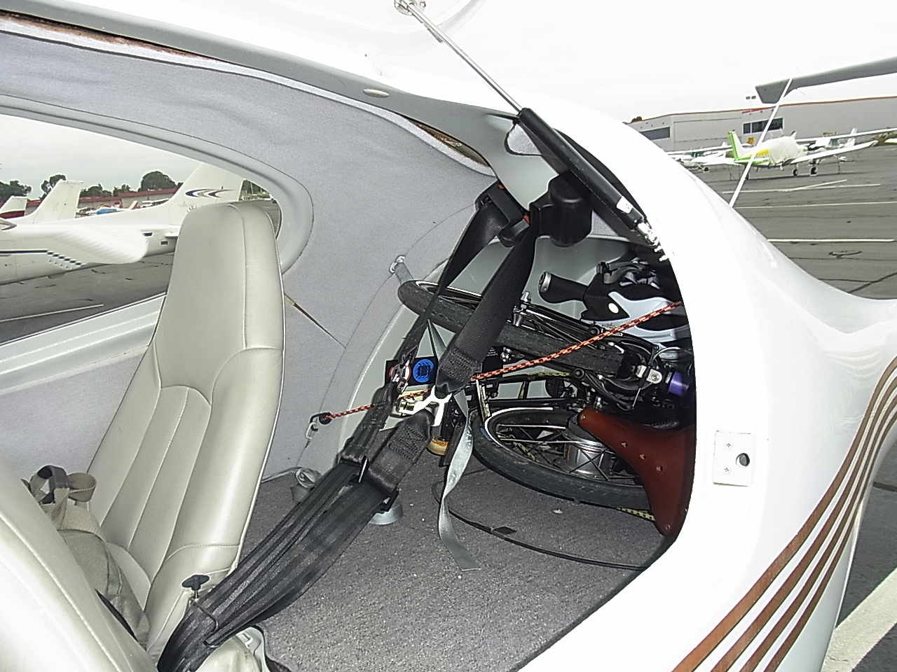
A mountain flying instructional flight, combined with the pilot's need to attend a meeting, meant I had a three plus hours to myself. Once again, I packed my Bike Friday Tikit and did some cycling around Lake Almanor. 

Tikit, secured in DA40 baggage area
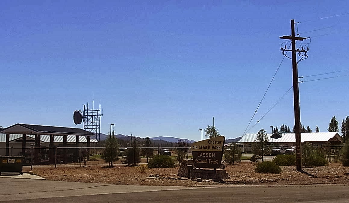
Upon arrival, I discovered the rear fender had given up the ghost. The design is somewhat suspect: Two metal washers, sandwiched around a hole in the plastic fender, secure the rear of the fender to the Tikit's folding rack. A bit of pressure in the wrong place (such as when stuffing the bike into a cargo hold) and the plastic is broken. Luckily, I scrounged a bit of aviation safety wire from the kind folks at the FBO at Chester Rogers Field and managed a makeshift repair. With some pointers from the woman at the FBO, I elected to circumnavigate Lake Almanor starting out to the south.

No bubblegum required ...

Air Attack Helicopter


Wide shoulder/bike lane


Empty Spillway
Minimal/no bike lane on the East/North side of the lake

Rolling hills, less shade on the north side of lake


Entering Chester, CA

Arriving in Chester, I stopped for a double espresso and a cookie at the Coffee Station. Having had time to think about the routes I've cycled in SoCal, the California Central Coast, and now the northwest Sierra, the idea occurs to me that at some point I'd like to connect the dots. Cycling from the Bay Area to San Diego would be an interesting challenge. Of course, I'll need plenty of sandwiches, cheese, bananas, and of course, hardboiled eggs ...

Sunday, September 15, 2013

SoCal Cycling

Events conspired and I found myself visiting Southern California twice within a week's time. Ever aware of my cycling goal of logging 4,500 miles this year (currently just over 4000 miles) and the effect that traveling might have on my cycling routine, I again put my folding BikeFriday Tiki to good use. On the first trip I drove to San Diego. The second trip was an instructional flight in a DA40 with an overnight stay in Temecula. In both cases, I packed my Tiki and logged a few good rides.

We've driven to San Diego many times, but usually choose make it a humane, two-day trip via US 101 with an overnight stop on the Central Coast. This time I drove solo with our two Basenji, straight (pretty much) to San Diego in 10.5 hours with three minimal rest stops. It would have been 9.5 hours, but there was an hour delay on I-5 due to an accident involving a truck hauling what looked like tomatoes. Spending one hour to cover 2 miles didn't help my mood. Approaching the Gorman Pass, Waze decided it was best to route me through the Antelope Valley via the Pearblossom Highway to I-15 rather than through the LA basin. Towering cumulonimbus clouds loomed in the sky as we drove along the two-lane blacktop and a light rain began falling. My mood improved, at least until I hit Friday rush hour traffic near Riverside.

A tree grows in San Diego!

There are few areas of grass or dirt in the area surrounding the downtown San Diego hotel where we were staying and that had our dogs frustrated. Clearly they wanted to get their feet and their noses in contact with the earth, not cement, brick and asphalt. We walked four blocks before we found a park and they were much happier. It's amazing how we humans have become accustomed to paving over the natural world.


With a heat wave gripping SoCal, I decided to rise early the next morning and do a bike ride while the air was cool. Staying along the Pacific Ocean would help, so I researched various bike rides with GoogleMaps (really liking the new bike routing on the iPhone) before choosing a trip to Point Loma and the Cabrillo National Monument. There were plenty of cyclists and walkers on the trail near Harbor Drive. Most were friendly, save the competitive group of cyclists I encountered. One of them dismissively informed me that my Tikit was "a piece of crap." Whatever ... I still enjoyed the nice 18-mile loop, a good climb up Talbot Street, and the clear skies and the cool air. With great weather and stellar views, you just want to get out and move when you're in San Diego. It's no wonder so many of the residents are physically active and very, very fit.


View of Cabrillo, North Island NAS in the distance

Nice hill on Talbot Street
My wife joined us on the drive back and we did our usual overnight stop at Pismo Beach. The next morning we agreed I would cycle to San Luis Obispo and we'd meet up at one of our favorite breakfast stops, the Big Sky Cafe. GoogleMaps routed me through Price Canyon and the Edna Valley, a well-known wine region. Under overcast skies I found the bike lanes and paths were pretty good, though parts of the bike lane on Price Canyon Road were overgrown with weeds, forcing you to move into the vehicle lane to pass. I was unaware that there were oil rigs in Price Canyon. I first smelled, then saw the oil drilling facilities.


We enjoyed a good breakfast at the Big Sky Cafe and the rest of the drive home was made better by a bit of morning exercise.

The next morning after arriving home, I packed my Tikit into a DiamondStart DA40 for a trip to French Valley airport and an overnight stay in Temecula. I've decided that removing the left pedal makes it easier to pack the Tikit into any vehicle and carrying the appropriate allen wrench is easy enough.


The midday 8.5 mile ride from the French Valley airport to the hotel was hot and GoogleMaps decided to route me through some residential neighborhoods to avoid a main road that had high-speed traffic and a minimalist bike lane. In general, Temecula and Murrieta have good but fragmented bike infrastructure: Crossing I-15, for example, is a dicey affair because there are only a few roads that make the crossing and none that I found had any bike lanes or markings at all. I rode around Temecula that afternoon, but found it boring and dissatisfying. Maybe it was the heat or perhaps it was a spread-out town plan based on petroleum fueled transportation? If/when the zombie apocalypse comes, I fear towns like Temecula are not going to fare well. That night I walked around Old Town and had dinner in preparation for the next morning's ride: A trip to the nearby town of Fallbrook and back.


I got an early start and the air was pleasantly cool. GoogleMaps routed me to Fallbrook via Rainbow Canyon Road (the old Route 395). I had seen few cyclists in Temecula the day before, but I saw quite a few riding the roads outside of town. There were some good climbs along the way and plenty of nice scenery. The bike lanes were generally good, though the pavement was a bit rugged on parts of Rainbow Canyon Road.


Avocado Capital

After a 30-plus mile ride, I recuperated in air conditioned comfort at the hotel before checking out and heading back to the French Valley airport. Halfway to the airport, I took refuge from the midday heat at Jax Bicycle shop, where the staff kindly pumped up my tires and replenished my water bottle. I'll be doing more cycling on my Bike Friday Tikit soon, this time in the Sierra Mountains. More details as they become available ...

Wednesday, September 4, 2013

Throwing off the Chain

After five thousand-plus miles of belt-drive bicycling, I wanted to share my experiences with a Rohloff equipped Proletariat (my primary commuter) and a Shimano Nexus equipped Bike Friday Tikit. Belt-drive technology and internally-geared hubs promise lower maintenance, quiet operation, flexible gear shifting, and freedom from oily/greasy chains. With a few caveats, I've found these advantages to be real and have been very pleased with belt-drive technology. I know there are many in the cycling community who have rejected internally-geared hubs (IGHs) in general and belt-drive bikes in particular. Whether or not the advantages of IGH/belt-drive will be realized for you depends on several factors. I'll start with my experience with the Bike Friday Tikit and conclude with the Rohloff-equipped Proletariat.

CDrive versus Gates

When I purchased the Bike Friday Tikit, I opted for lower-priced CDrive-equipped model and that was a mistake. The CDrive worked for a while, but after about 300 miles I found the belt slipping when pulling away from a stop in a slightly higher-than-normal gear. The belt "snubber" that held the belt firm against the rear pulley (meant to prevent this behavior) actually seemed to cause the belt to deteriorate. After 500 miles of use the, belt slippage became too annoying and I had the good folks at Cycle Monkey replace the CDrive with Gates Center Track pulleys and belt. Changing to the Gates components meant replacing the crankset, but I was able to re-purpose that crankset on my Prole. With the Gates equipment installed, the belt slipping stopped. If I had it to do over again, I would pony up the extra cash for the Gates belt-drive from the get-go.


Shimano Nexus

I originally had an 8-speed Alfine on my Prole and still have an 8-speed Nexus on the Tikit. My conclusion is that the Shimano 8-speed hubs (I have no experience with the 11-speed Shimano Alfine) are not ideal for belt-drive applications. Belts require tension and perhaps it is that force that causes Shimano's internally-geared hubs (IGHs) to make unhappy noises. And then there are occasional missed shifts, occasional slipped shifts, and the general feeling that things are not right. My theory? The Shimano design uses a large diameter roller bearing on the drive side and it isn't up to the stress that the belt tension produces. The Rohloff uses sealed bearings on both the drive and non-drive sides. A heavier, but more robust and reliable design.

I can live with these shortcomings on the Tikit for shorter, intermodal style transportation. I seldom ride the Tikit more than 8 or 10 miles at a time, but when I do ride farther the Shimano Nexus really starts to bug me. With the CDrive set-up, the ride characteristics became intolerable. With the Gates equipment and the Nexus, the Tikit is quite usable. I'd like to put a Rohloff on the Tikit, but will have to keep saving for that upgrade.

Proletariat, mit Rohloff

On the brighter side, my Rohloff-equipped Prole has turned out to be everything I hoped it would be. After over 4,000 miles of cycling pleasure, it is difficult to describe the Rohloff without using superlatives. The Rohloff SpeedHub is rock-solid, bullet-proof, solidly-engineered, confidence-inspiring, ultra-reliable. The Rohloff is more expensive than the Shimano IGHs, but it's in a totally different class.

Proletariat, with recently added drop bars

After a year, I experienced stripped axle threads on the non-drive side of the Rohloff caused by a slightly too-short axle for the Prole's thick dropouts. That was quickly fixed, under warranty.

I noticed after 300 miles or so of use that the belt would start to become a bit noisy, making a slight squeaking/whirring noise. To stop the noise, I had tweak the belt tension every 300 miles or so. The culprit turned out to be rear axle slippage in the horizontal dropouts. Reinstalling the original tensioning nut that I had removed from the drive side was the solution. If you have a frame with horizontal dropouts and are using a belt-drive, I suggest using a drive-side tensioned arrangement such as the Surly Tuggnut.


Another issue was the bearing seal on the drive side began to weep a small amount of oil after about 3,500 miles of use. Again, that problem was fixed under warranty and has not returned. The leak may have been caused by me running a bit too much tension on the belt. It took quite a while to clean the mess off of the Gates belt with mild soap and water!

Good Tension, Good Alignment

Many bike mechanics tension Gates belts solely by feel. I like the Gates iPhone App because it lets you set the tension by plucking the belt like a guitar string and reading the vibrational frequency. You'll need a quiet environment and a bit of patience. Avoid too much tension. I suspect that might lead to the aforementioned bearing seal problem.


I've also discovered that the rear wheel alignment needs to be pretty precise if you want quiet belt operation and consistent tension across the rotation of the belt and crankset. I currently tension the belt on my Prole to about 45Hz with good results.

Bicycling Unchained

What's the best part of having a well-maintained and properly-adjusted belt drive bike? Belt-drive bikes are uncannily quiet and smooth, especially with the Rohloff. Be sure you have a bell on your bike that you can ring as a courtesy to pedestrians who might not hear you approaching. When it comes to Rohloff versus Shimano, I've become a SpeedHub evangelist: The Rohloff is not just a little bit better, it's a whole lot better. You get what you pay for and in my book, the Rohloff Speedhub is worth the cost.

Thursday, August 8, 2013

Cars, Trains, Planes, Folding Bikes & the Dumbo

Whether it's commuting to work, a shopping trip, or just running errands, it's all too easy to get into a fossil-fueled rut that can only be escaped by conscious and physical effort. Intermodal transportation to the rescue! I'm not referring to intermodal freight transportation, though the idea is similar for human beings. I'm refereing to combining a folding bike like a Bike Friday Tikit, Brompton, Dahon or other make with one or more modes of motorized transportation. This is where a folding bike really shines, even if it's not your regular, go-to bike. Last week I needed to ferry an airplane from Palo Alto to Oakland and the combination of BART with my folding bike provided an elegant, physically active solution. What's more, it afforded me the experience of crossing the Dumbarton Bridge by bike.

I needed to carpool to Concord for a morning meeting before heading to Palo Alto, so I loaded my Tikit into my car. After the meeting, I dropped my passenger off near Tunnel Road and headed to Alameda. My plan was to park just across the estuary in Alameda, ride to the Fruitvale BART station, board a train to Union City, then cycle the rest of the way to Palo Alto. I could have parked in the BART parking lot, but that would have cost me $1.50. Besides, I would eventually end up at the Oakland Airport and would have to ride farther to get back to my car. I was lucky to arrive on the Fruitvale BART platform just as a Fremont train was arriving. The trip to Union City took about 30 minutes.


Arriving at Union City, I was pleasantly surprised by a clean, European-style train station. So I snapped this photo before heading out to cross the Dumbo. A while back a friend sent me a link to a study that compared the condition of BART stations with the income of the local residents. My personal experience would suggest there is indeed a correlation between the average income of local residents and the general spiffiness or shabbiness of their local BART station (see graphic below). Ah, America! Land of (in)Equality!


This trip also provided a test of the new GoogleMaps app on the iPhone which now (finally!) provides bike directions. I don't have a handlebar mount, so I put my iPhone in my shirt pocket so I could (mostly) hear the GoogleMaps voice prompts. An exciting part of the route involves crossing the I-880 overpass on Decoto Road, a particularly dicey endeavor given the poor lane striping, complete lack of signage warning drivers or the presence of bikes, and the need to cross multiple freeway entrance/exit ramps. Next comes an relatively unique, dedicated bike/pedestrian-only underpass beneath the southbound I-880 exit ramp to Decoto Road. It empties onto a two-lane path that is at once secluded and creepy (several cul de sac paths to homeless encampments), yet picturesque (tree-lined and next to an active farm). The buckled asphalt resembles a washboard and requires one to slow to walking speed in several areas.


Next you double-back onto Lake Boulevard to an overpass across Decoto to Jarvis Avenue.


Once on Jarvis, the bike lane is well-marked, well-paved, and quite civilized as you make your way through a mixed residential-commercial neighborhood. Approaching Gateway Boulevard, the area becomes more business park and light industrial in flavor. The left turn onto Gateway has no signs to lead cyclists to the Dumbarton Bridge and the traffic signal will not detect the presence of bicycles. I waited and waited before finally just running the red light and making a left turn. Same thing for the left turn onto Thornton Avenue. Thornton has wide bike lanes, reasonable pavement quality and more wide-open landscape.


Turning onto Marshlands leads you into the Don Edwards San Francisco Bay Wildlife Refuge and pavement that is best described as rustic. I experimented with riding in the car lane and the bike lane/shoulder. The pavement appears equally bad in both areas, but it's actually a bit smoother on the shoulder. Soon you're paralleling the causeway that leads to the Dumbarton Bridge, along the edge of marsh that used to form the salt evaporation ponds of the Leslie Salt Company, founded in 1901 and acquired by Cargil in 1978. These are gradually being restored to their wetland salt marsh and the odor of the mud is ... pungent.

Marshlands Road, looking westward toward the Dumbarton Bridge
The pavement on the section of Marshlands Road leading up to the Dumbarton Bridge deserve a d-minus rating. It's not so bad as to instantly ruin your bike's tires, but rough and tiring to ride on. The chain-link fence that separates Marshlands from the bridge traffic is pretty tired, too. Some sections have wooden slats that block the wind and dust, but most sections do not.


An obvious bike commute comparison for the Dumbarton Bridge is the Posey Tube. The good news is that at eight feet, the Dumbarton Bridge path is far more usable than the sidewalk on the Posey Tube. The noise level on the Dumbarton Bridge is not as loud as in the Posey Tube, but it's not what one might call peaceful. The bad news is that the design of the Dumbarton path makes the accumulation of trash and debris a problem, as this blogger so eloquently describes.

This section was actually pretty clean. Other parts were debris strewn.
The cement K-rail that separates eastbound motor vehicle traffic from the two-land path on the south side of the bridge is barely adequate. It does not stop sand, grit, and debris from sandblasting poor bastards like me who are headed westbound toward the peninsula. Had I known, I would have brought a scarf to cover my face and neck. Passing trucks are particularly good when it comes to this unwanted dermabrasion. And if a truck were to blow a tire or run over debris on the roadway, it could easily catapult shrapnel into the pathway and likely would be fatal for a cyclist or pedestrian. If you ignore these issues and turn your back on the noise and the blowing sand from the vehicle traffic, the views can be quite lovely.


Exiting the bridge on the western side, the pavement is far better than what is found on Marshlands. Perhaps the difference is that you're now in San Mateo county, adjacent to well-heeled Palo Alto and Menlo Park? At any rate, on this side of the bridge, cyclists get a bike path that is altogether separate from the vehicle traffic. Almost ...


Nice pavement, but no barrier at all from motor vehicle traffic?
My goal was to get to the Palo Alto Airport and the Bay Trail runs right by it. Unfortunately, the trail comes about 500 yards short of joining the bridge bike path. This necessitates crossing University Avenue at a particularly busy traffic light to join the bike lane into East Palo Alto. At least there are crossing switches you can press to eventually get a walk signal. Winding my way through the residential streets I could hear GoogleMaps periodically barking instructions, but I just followed my nose and found the Bay Trail on my own. Parts of the Bay Trail are gravel, parts are paved, but even the gravel sections seem smoother than Marshlands Road on the eastern side of the bridge!

So close, and yet so far ...

The Bay Trail passes adjacent to the marshy areas and eventually leads to the golf course on the western side of the Palo Alto Airport. Soon I was loading my folding bike into the aircraft I needed to ferry and just a few minutes later, the engine run-up complete, I departed straight up the Bay for Oakland. The South Tower controllers coordinated a straight-in landing on runway 33 which provided a short taxi to the hangar where this aircraft will temporarily be stored. Then I was ready to unfold the Tikit, head into Alameda to where I had parked my car, fold up the Tikit one last time, and drive home for the evening. Car, train, bike, plane, bike, car: All in all, a challenging, yet pleasing day of intermodal transportation.